Brisbane City Council's planning scheme is comprehensive, but when evaluating residential...
MBRC's zoning framework has a lot of moving parts - multiple zones, precincts within those zones, and overlays on top of that. It can get confusing quickly, so here's what I look at as a developer when evaluating residential properties - and what I think is useful to know. You will find a quick-reference table at the bottom of the article.
Understanding the fundamentals can help spot development potential, answer client questions, and position listings correctly. It's particularly useful in growth areas where infrastructure timing and zoning can make a big difference to value.
Quick disclaimer: This is high-level stuff to help you understand the basics and have smarter conversations. For anything specific, you'll want to verify with Council or get a planning consultant involved - I'm just sharing what I look at.
Why This Helps
Here's what zoning knowledge gives you:
- You can spot when a property might have development potential
- You don't get caught out when clients ask "can I subdivide?"
- You understand why one street has townhouses and another doesn't
- You can speak to a property's potential
Worth knowing: Not all "General Residential" properties are the same - the precinct changes everything. That's probably the biggest thing to understand.
How I Think About the Hierarchy
I work top-down through three layers:
ZONE (what area type is this?)
└─ PRECINCT (what specific type within that zone?)
└─ OVERLAYS (any special rules?)
My simple analogy: Zone = the neighborhood. Precinct = the street. Overlays = anything special about that property.
Always check zone first, then precinct, then overlays.
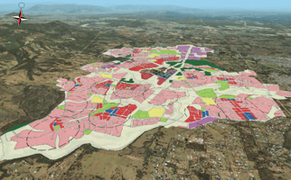
Example: How one side of the street can allow townhouses and the other doesn't

The image above shows an area of General Residential Zoning and has four different precincts. This is why checking the precinct matters - same zone (General Residential), different precincts, completely different development potential.
The Residential Zones (What I Look For)
ZONE 1: GENERAL RESIDENTIAL ZONE
Official description: "Provides for residential activities supported by local facilities, employment and activity centres that cater for local residents."
My take: This is your standard residential zone - houses, some townhouses, and units depending on the precinct.
The 4 Precincts:
| Precinct | Density | What You'll See | Where You'll Find It |
|---|---|---|---|
| Suburban Neighbourhood | Lower | Houses on traditional residential lots, as well as some houses on narrow lots, and dual occupancies | Most established suburbs |
| Coastal Communities | Lower-Medium | Houses on traditional-sized residential lots |
Coastal areas |
| Urban Neighbourhood | Medium-High | Medium and high-density housing, including apartments, plexes, row or terrace housing, townhouses, and managed communities | Near major centres & transport |
| Next Generation Neighbourhood | Medium-High | Houses on a variety of lot sizes, including traditional and narrow lots, dual occupancies (traditional and loft), row or terrace housing, plexes, low and medium rise apartments, townhouses and managed communities | Throughout growth areas of MBRC |
What's usually allowed (broadly speaking):
- Build a house
- Dual occupancy (acceptable in Next Gen and Suburban)
- Small-scale units/townhouses (Next Gen & Urban are more flexible)
- Granny flat/secondary dwelling (usually Suburban and Next Gen)
- Low-rise apartment blocks in Urban Neighbourhood
Common questions:
- "Can I subdivide?" → Mainly possible in Suburban and Next Gen (check minimum lot sizes)
- "Can my neighbor build units?" → See if they're in Urban or Next Gen
ZONE 2: EMERGING COMMUNITY ZONE
Official description: to (a) identify land that is suitable for urban purposes and conserve land that may be suitable for urban development in the future; (b) manage the timely conversion of non-urban land to urban purposes; (c) prevent or discourage development that is likely to compromise appropriate longer term land use.
My take: Future residential areas. Development readiness varies massively depending on infrastructure availability. Often, developments in this zone are large-scale as they need to be master-planned with the council and utility providers.
The 2 Precincts:
| Precinct | Official Purpose |
|---|---|
| Interim Precinct | Land that may be suitable for future urban development - allowing interim uses that won't compromise longer-term planning |
| Transition Precinct |
Identify and conserve land that may be suitable for future urban development. The idea is that it can progress towards a next genertion style neighbourhood |
What buyers get:
- Future residential neighborhoods (some areas not fully developed yet)
- Potential longer-term investment play
- Current opportunities ready for development - subject to local instruments and availability of infrastructure
The critical bit: Each property's access to sewer, water, and stormwater determines how 'development-ready' it actually is. Two properties in the same zone can have completely different timelines.
What's usually allowed:
- Limited residential development (depends on structure plans)
- Some interim rural uses
- Check for local plans and TLPIs (temporary restrictions)
What I watch for:
- "When will infrastructure arrive?" → Check Council's and utility plans - timelines vary a lot
- What does the council have planned for this area? Temporary Local Planning Instruments (TLPIs) often apply
- It could be years before services arrive
- Don't assume it's "ready to go" - infrastructure is everything
- Always verify water/sewer/stormwater connections before making claims
Where you'll find it:
- Morayfield South
- Parts of Caboolture West (outside NDP1)
- Narangba East (with TLPI restrictions)
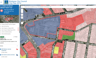
Example of Transition Zoning
The pale pink parcels are Emerging Community - Transition Precinct (future development). The brown/purple is Rural Residential Zone (acreage lifestyle blocks). Top right is Next Generation Neighbourhood (already developed with higher-density housing). So, you can see where the council is expecting housing growth when certain conditions are met.
This demonstrates you can't assume all land in a perceived growth corridor has the same development potential. Zone and precinct tell you where each property sits in the pipeline.

ZONE 3: RURAL RESIDENTIAL ZONE
Official description: The Rural residential zone includes areas of very low density residential development generally located on the edge of urban areas. Properties generally range from 3,000m2 to two hectares in size.
My take: Acreage lifestyle - bigger blocks, semi-rural feel.
| Density | What You'll See | Where You'll Find It |
|---|---|---|
| Very Low | Large detached houses, rural sheds, hobby farms | Fringe areas of Narangba, Caboolture, Burpengary, along with Dayboro, Samford, etc. |
What's usually allowed:
- One dwelling per lot (plus granny flat)
- Rural activities (horses, chickens - check local laws)
- Home business (needs approval)
What I watch for:
- "Can I subdivide?" → Be careful here - lots of "no further reconfiguration" overlays and varying minimum lot sizes
- Often no town sewer (septic systems are common)
- Overlays like bushfire risk and flooding
- Minimum lot sizes vary - e.g., it could be 3,000m2, or it could be 2ha - always check the specific property
ZONE 4: RURAL ZONE
Official description: Up to 50% of City of Moreton Bay land can be found in the Rural zone, which is characterised by productive farmland, scattered housing and natural areas. The Rural zone is generally located outside existing urban areas and comprises land with widely varying lot sizes. The State Government’s South East Queensland Regional Plan 2009-2031 imposes restrictions on development in the Rural zone, limiting subdivision to minimum lot sizes of 100 hectares.d, scattered housing and natural areas.
My take: Working farms and large rural properties - not typically residential development opportunities.
| Density | What You'll See | Where You'll Find It |
|---|---|---|
| Very Low | Farmhouses, sheds, cattle/crops, scattered dwellings | Throughout rural areas |
What's usually allowed:
- One dwelling per lot (typically)
- Agricultural activities
- Rural industry (needs approval)
- Some farm-stay/tourism uses
What I watch for:
- "Can I subdivide?" → Usually very hard - large minimum lot sizes protect agricultural land
- No town services (septic systems required)
- Overlays like bushfire and natural hazards are common
- Very limited residential development potential
ZONE 5: TOWNSHIP ZONE
Official description: The purpose of the Township zone is to ensure future development is of a scale and design that is consistent with the township role and function and maintains its unique character.
The Township zone incorporates a range of small to medium urban settlements in rural parts of Moreton Bay including D’Aguilar, Dayboro, Samford, Wamuran and Woodford. A mix of residential, commercial and industrial uses can generally be found within the Township zone.
My take: Country town living - small settlements in rural areas.
The 2 Precincts:
| Precinct | What It Allows |
|---|---|
| Township Centre Precinct | Small commercial/retail, mixed-use |
| Township Convenience Precinct | Residential with small local services |
What's usually allowed:
- Residential dwelling
- Small home business
- In Township Centre: mixed use (shop + residence)
What I watch for:
- Limited services vs urban areas
- Check water/sewer availability
- Heritage or character overlays (especially Samford)
Local Plans (The Quick Version)
Some parts of Moreton Bay are covered by Local Plans - mapped, place-specific planning rules that sit alongside the standard zones. In these areas, development is assessed against local plan precincts and the local plan code, not just the underlying zone. Current examples in MBRC include Redcliffe/Kippa-Ring, Caboolture West (Waraba), and Woodfordia. If a site is inside one of these areas, expect extra precinct provisions (and sometimes Neighbourhood Development Plans) - so it’s worth checking the local plan mapping early or getting planning advice.
Not going to cover Local Plans in this article.
How You Can Quickly Check Zoning
My 3-step process:
- Go to Council's My Property Lookup: MyPropertyLookUp
- Enter the address
- Check: Zone → Precinct → Overlays

What you will see:

What I'm looking for:
- Zone (big picture)
- Precinct (specific type)
- TLPIs (temporary restrictions)
- Overlays (flood, bushfire, heritage)
The Final Take
This is high-level stuff to assist in conversations with clients. Every property is different, and you should always verify specifics with Council or get a planning consultant involved before making promises.
My approach: Work top-down - Zone → Precinct → Overlays (use the Lookup Tool). If you're dealing with Emerging Community or Next Generation, dig a little deeper before committing to anything.
Questions? Happy to chat.
MBRC Residential Zones & Precincts - Quick Reference
| Zone | Precinct | What You'll See |
|---|---|---|
| General Residential | Suburban Neighbourhood | Houses on traditional residential lots and dual occupancies. Think 600m2 lots. |
| Coastal Communities | Houses on traditional-sized residential lots | |
| Urban Neighbourhood | Medium and high-density housing, including apartments, terrace housing, townhouses, and managed communities | |
| Next Generation Neighbourhood | Houses on varied lot sizes, dual occupancies, terraces, low- to medium-rise apartments, and townhouses. Small lots and higher-density housing | |
| Emerging Community | Interim Precinct | Potential/limited development - land that may be suitable for future urban development with interim uses. Under investigation. |
| Transition Precinct | Dwelling houses on developed lots - land transitioning to urban residential (next gen) use. Think larger developments with lots of planning requirements | |
| Rural Residential | (No precincts) | Large detached houses, rural sheds, hobby farms on acreage blocks. Four categories of development: 3,000m2 lots, 6,000m2 lots, 2ha lots, and no further reconfiguration. |
| Rural | Agriculture Precinct | Farmhouses, sheds, cattle/crops, scattered dwellings on large rural properties |
| Township | Township Centre Precinct | Small local convenience centre - limited retail/services and community uses to meet day-to-day needs of the local catchment. |